• Thank you for visiting HeavyEquipmentForums.com! Our objective is to provide industry professionals a place to gather to exchange questions, answers and ideas. We welcome you to register using the "Register" icon at the top of the page. We'd appreciate any help you can offer in spreading the word of our new site. The more members that join, the bigger resource for all to enjoy. Thank you!

Dredging in Seward Ak.

Lashlander

Senior Member
Joined
Jan 4, 2007
Messages
1,226
Location
Kodiak Ak.
We got the bottom survey in today on this. It was done with an Airplane. This is the first time I've seen this technology put to use in this type situation. The numbers haven't been crunched yet so don't have the yardage.
I thought this was wild. The black in the center is the dock. You can sure see where we made the cut.
 

Attachments

  • Above34_RED3 (Small).jpg
    Above34_RED3 (Small).jpg
    48.1 KB · Views: 1,065

RonG

Charter Member
Joined
Dec 2, 2003
Messages
1,833
Location
Meriden ct
Occupation
heavy equipment operator
What is their reference point when they say 33.064' deep?Is it mean sea level or the dock or low tide or what?Is it 33' below the surface when the image was taken and then they calculate where the surface was at that time?
Do they collect that data before and after to see how much you removed?
Great series of pics as usual just to remind us all of the stuff we don't know.Ron G:)
 

Lashlander

Senior Member
Joined
Jan 4, 2007
Messages
1,226
Location
Kodiak Ak.
Hey Ron, I'm not a 100% sure. I think that tag is referencing the red in the center along side our cut. The footage would be from 0 tide. Our cut was a minimum of minus 37' and the tide doesn't get that low to be our cut. I have seen this used to chart shorelines before but have never seen it used for this. Always before they've had a computer with GPS in a boat and run a grid patten. It maps the bottom and quantities are taken off that. They do one before and after to get the yardage. Before I resized the pic you could tell which way we dug because of the sweep marks in the mud. Hard to believe they can get that from flying over in a plane when he water is that deep.
They were hoping to have the yardage figures early next week.
 

Big Iron

Well-Known Member
Joined
Oct 16, 2006
Messages
219
Location
Oregon
Occupation
Project Manager
Wow!!! Never knew they could do that from the air. How accurate can they get with that technology?
 

Lashlander

Senior Member
Joined
Jan 4, 2007
Messages
1,226
Location
Kodiak Ak.
I had to change the top bevel gear for travel in one of those machines once and generally lost any desire I had to work on them. The spiders are big and heavy, the shaft is big and heavy and soft and the bevel gears eventually turn into a lot of razor sharp splinters when they die. The thing I liked about them was that they generally worked for twenty years at a time before you had to do a job like that.


Hey John, thought you might get a kick out of this. We've had a leak in the rotator joint to the brakes in the lower unit. Finally got time to tear it down and repack it. The gears are a little rough but they cost 30 grand to replace. Since it took 50,000 hours to get this far I think they have a few more hours in them.
 

Attachments

  • Lash 109 (Small).jpg
    Lash 109 (Small).jpg
    52.3 KB · Views: 960
  • Lash 119 (Small).jpg
    Lash 119 (Small).jpg
    65.4 KB · Views: 995
  • Lash 116 (Small).jpg
    Lash 116 (Small).jpg
    64.9 KB · Views: 977
  • Lash 111 (Small).jpg
    Lash 111 (Small).jpg
    65.9 KB · Views: 958
  • Lash 112 (Small).jpg
    Lash 112 (Small).jpg
    66.1 KB · Views: 976

John C.

Senior Member
Joined
Jun 11, 2007
Messages
12,870
Location
Northwest
Occupation
Machinery & Equipment Appraiser
Lashlander,

Thanks for the memories.

Those gears look to be just getting some experience. They will last a long time yet. There used to be a bulleton out on that swivel under the cross shaft though. Link-Belt had an update out with a new joint. I almost got burned on the one I did, cause the owner's mechanic just wanted new seals in the bugger. I made their mechanic sign the service report that he refused to put the new swivel in. Three days later we got a phone call from the owner at 5:30 PM saying the swivel was leaking and it was our fault. He wanted us there that night to fix the problem at my expense. I faxed him a copy of the service report and told him we would be happy to be up there that evening to fix the problem but he was on the hook for all the travel, mileage and overtime. He declined and said his mechanic would take care of the problem.

She's a dinosaur but there's still a lot of money to be made with her yet.

Good Luck!
 

Wolverine69

Member
Joined
Mar 29, 2007
Messages
7
Location
USA
Hey Ron, I'm not a 100% sure. I think that tag is referencing the red in the center along side our cut. The footage would be from 0 tide. Our cut was a minimum of minus 37' and the tide doesn't get that low to be our cut. I have seen this used to chart shorelines before but have never seen it used for this. Always before they've had a computer with GPS in a boat and run a grid patten. It maps the bottom and quantities are taken off that. They do one before and after to get the yardage. Before I resized the pic you could tell which way we dug because of the sweep marks in the mud. Hard to believe they can get that from flying over in a plane when he water is that deep.
They were hoping to have the yardage figures early next week.

I wonder if they're using a laser in the airplane to do the bottom profiling?
 

akpolaris

Active Member
Joined
Jul 18, 2011
Messages
38
Location
Seward, Ak
super interesting post. I've lived in Seward for over 25 years and this is great stuff to see. I usually just see the work going on from the shore. Thanks
 

akpolaris

Active Member
Joined
Jul 18, 2011
Messages
38
Location
Seward, Ak
During the earthquake in 64 the whole shoreline rearranged itself. There were large fuel tanks, docks and the railroad ran along the shore from north to south. When folks did along the shore finding an entire rail cars is not unusual. Lots of stuff went under during that quake and was never seen again. Most beautiful scenery of anywhere I have ever lived as long as the skies are clear.

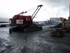
DigDug, the barge wasn't to slick with the mud on it. The mud seemed to be a little gritty. The barge had a concrete deck. It was a little strange operating the loader on a moving platform though.

Stretch, I don't own the company. I've worked for them for over 18 years now and the owners are trying to talk me into taking it over but I'm just a worker bee.

DPete, We dug up a lot of railroad track and wood piling on this job. The other operator did a little panning of the spoils when I was digging. Never found anything good though.

Big Iron, Seward is a beautiful place when the weather is decent. We've done a lot of work there. All our jobs have been in the fall to spring so we miss the tourist season. No crowds and friendly people. Its one of my favorite places to work.

Thanks for everyones comments. Heres the last of the pics.

A couple pics of off loading.

View attachment 16434
View attachment 16435

Once we got away from the dock the material got a little sandy so we were able to get a decent load on the barge.
View attachment 16436
View attachment 16437

Rather than spend the time to anchor up I chose to drive piling to moor the barges when we were off the end of the dock. This kept us from having to clam around our anchor lines.
View attachment 16438
 
Top